

Nicaragua Geography and Maps


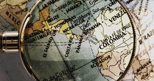
With a total area of 130,370 square kilometres (50,336 square miles), Nicaragua is the largest country in Central America. It borders Honduras to the north, Costa Rica to the south, the Caribbean Sea to the east and the Pacific Ocean to the west. Known as the “Land of Lakes and Volcanoes”, the landscape of Nicaragua is dotted with volcanoes and various waterways including lakes, lagoons and rivers. The main rivers are the San Juan which extends to Costa Rica and the Rio Grande.
Geographically, Nicaragua can be divided into three major zones: the Pacific lowlands, the central highlands and the Caribbean lowlands. Central America’s largest freshwater lakes, Lago de Managua and Lago de Nicaragua are located in the Pacific lowlands. Despite being relatively flat, there is a line of partially active volcanoes that run through this zone.
The central highlands are cooler than the Pacific lowlands and have points that span 900-1,809 metres (2,953-5935 ft) in height. The western slopes of the highlands are dry and are popular farming areas while the eastern slopes are some of the wettest places in the world. The Caribbean lowlands are hot, humid and tropical. The largest of Nicaragua’s three geographical zones, these lowlands make up more than 50% of the country.
Extend Your Trip
After your Nicaragua tour, why not consider another of Goway's Latin America tours? These include a large selection of other exciting countries in Central and South America. We offer Chile vacation packages and Easter Island tours, Ecuador vacation packages which include Galapagos cruises, Peru vacation packages which include Machu Picchu tours and Brazil tours including Iguassu Falls tours among many others.
Get a Trip Quote Order a Brochure